

Bethlehem Live Weather Camera sponsored by St. Luke's University Health Network
-
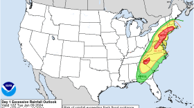
 Another powerful winter storm is set to hit the region, bringing concerns of widespread flooding and high winds Tuesday into Wednesday.
 -
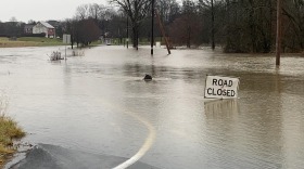
A severe rainstorm is expected to cause flooding that may impact roadways throughout the Lehigh Valley.
-
A Muhlenberg College professor has launched a campaign this month to inform residents about the health risks of radon, as well as improve access to testing and mitigation. The Lehigh Valley is home to the highest radon levels ever recorded in Pennsylvania.
-
Sunday evening will see a ‘close approach’ between Saturn and the Moon. Though the two appear close in the night sky just after sunset on Jan. 14. However, in space, Saturn is almost a billion miles away, about 4,000 times more distant than the moon.
-
The Lehigh Valley and surrounding areas are under a flood watch from Tuesday afternoon through Wednesday afternoon, according to the National Weather Service.
-
-
With some parts of the Lehigh Valley under as much as 9 inches of snow, the National Weather Service says the storm’s not quite done yet.
-
Olivia Louise McMahon traveled to Dubai last month as part of Penn State University's delegation to the United Nations Climate Change Conference. Officials from around the world discussed how to limit the effects of climate change already present and prepare for further impacts.
-
The funding for four projects came from the Growing Greener and Act 167 grant programs, both through the state Department of Environmental Protection.
-
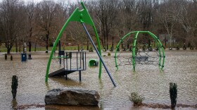
Emergency Management agencies at the county and state level, as well as cities in the Lehigh Valley say they're ready for whatever happens after the snowstorm: including a risk of severe and dangerous flooding.








-
“This is not just a one-day spike,” the weather service said in its forecast discussion. “Very warm and above normal temperatures will continue through the upcoming weekend.”
-
Officials and executives at the Lehigh Valley Economic Development Corporation's annual meeting Tuesday pulled back the curtains on Eli Lilly's decision to open in the region.
-
The winter storm that prompted dire forecasts and a statewide disaster declaration largely fizzled in the Lehigh Valley, leaving the area with only moderate to light snowfall by Monday morning.
-
As the Lehigh Valley’s most recent blanket of snow rapidly melts away, Mother Nature appears ready to test the region’s patience all over again.
-
The early LIHEAP crisis numbers already represent a notable share of last winter’s total in the Lehigh Valley, according to data provided by the Department of Human Services.
-
An extreme cold warning, combined with a wind advisory also in effect, could mean wind chills as low as 20 degrees below zero for the region this weekend.
-
A webinar Monday brought together regional planners, engineers and industry leaders to explain how data centers operate and what their growth could mean for local communities.
-
Powering up on protein: As focus zeroes in on nutrition, here's how to navigate the nutritional mazeProtein is king in the world of nutrition at the moment, but there are plenty of questions surrounding the trend. Let's take a look at what it is, where to get it from, and how to navigate the complex world of nutrition.
-
Month-to-date snowfall in the Allentown area now stands at 20.8 inches, nearly triple the normal January average of 7.7 inches, according to the National Weather Service.
-
The storm dropped a record 11.8 inches of snow on Lehigh Valley International Airport, breaking the old record of 10.4 inches for the date set in 1988.
-
Forecasters say the Lehigh Valley region could see 10 to 16 inches of snow and sleet accumulations, with a wintry mix of snow and sleet expected Sunday afternoon and evening. A winter storm warning remains in effect into Monday afternoon.
-
Lehigh Valley shelters are adding capacity as meteorologists forecast between 10 and 16 inches of snow starting Sunday.